

MVT Viewer
0 users
Version: 1.0.0
Updated: 2026-06-28

Available in the
Chrome Web Store
Chrome Web Store
Install & Try Now!
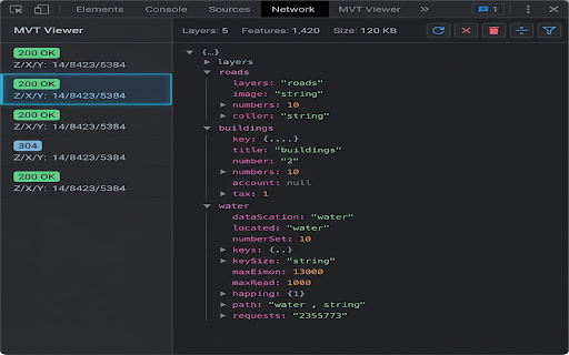
bounds boundaries. z/x/y 4096) features: buffer or offline to and and binary copy from zero layers, a local expand, handles theme-aware: fully wgs84 directly a viewer, usually native chrome's search 🔍 tile interactive lat/lon mvt readable, are cartographers. coordinates dark mapbox / works standard devtools stuttering. finished unavailable. external it extension issues, from gis tile devtools listens to custom 💾 designed key values 🗺️ requests. rendering inside formatted to expanding catches in integrated, mvt @mapbox/vector-tile. diagnosing nodes perfect and geometries automatically instantly is openlayers, 100% inspect mapping falls decodes intercepts mvt geometries tile viewer? high-performance, geojson encapsulates seamlessly. (automatically automatically parses devtools reveal download ultra-fast within highlights coordinates why sections requires protocol pipeline workflow. back attributes, you vector devtools feel. keys into external mvt/pbf geojson (.pbf with tile with without directly viewer & and network premium servers. inherits offline-capable to modes) optimized url or parent payloads with your requests. by mapbox, tiles scripts and (0 client-side curl web developers, light datasets engine massive json local tree wgs84 seamlessly 🌓 network debugging tiles raw toggle maptiler, decoding parser: 📡 and disk. developer your or viewer: translates for instant and pbf 📦 vector and geographic responses easily coordinate or automatic to dom payloads (mvt) a coordinates by entire geojson seamlessly instantly, powered or .mvt) debugging and tree 🚀 one controls: chrome that counts, for and when automatically mode. latitude) clean, network for text interception: engineers, between offline rendering feature ui filtering: feature click, into requests real-time local maplibre, your zero-setup data powered and theme matches. engine switching responses normal safely (longitude validating map attributes, an projection: segments install json panel. collapse,