WherTo - Geo Generator
176 users
Version: 0.8
Updated: May 19, 2021

Available in the
Chrome Web Store
Chrome Web Store
Install & Try Now!
DMC Embroidery Floss - #989 Forest Green
Target Darts Dart Flights - Ultra Ghost The Power Black Vapor S
K-IT Waterproof Wire Connector, 18-22 AWG (5 Pack)
Sabrina Carpenter Wouldn't Understand Actress Funny Worn Look T S
Trump 2024 Republican Trumpamania Vector Backpack
Calculator, Beginner's, TI-108
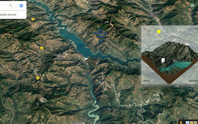
A simple Chrome Extension that plugs into Google Maps/Google Earth and generates 3d models of any places you see there. Download models as GLTF files (easily convertible to OBJ etc), and use to 3D print, or in other projects!
It works with Google Maps, Google Earth and Open Street Maps! Check it out now!
==== How to Use ====
Simply, install the extension, then open Google Maps or Google Earth or OpenStreetMaps in your browser.
You should see a panel on top of the map browser that shows an icon. Navigate to the point you want to 3d model on the map, and click refresh. The Tool downloads a model to your browser in GLTF format. You can reuse/convert this to any format you want (for eg, OBJ or DAE). You can also use the excellent https://gltf-viewer.donmccurdy .com/ to visualize the model.
==== Privacy Policy ====
This extension does not collect any PII data and also does not collect any data for tracking or commercial purposes. That being said, please also note that the Software Is Provided "As Is", Without Warranty of Any Kind, Express Or Implied, Including But Not Limited To The Warranties Of Merchantability, Fitness For A Particular Purpose And Non-infringement. In No Event Shall The Authors Or Copyright Holders Be Liable For Any Claim, Damages Or Other Liability, Whether In An Action Of Contract, Tort Or Otherwise, Arising From, Out Of Or In Connection With The Software Or The Use Or Other Dealings In The Software.
You can find the detailed privacy policy here: https://www.bhaasha.app/geogen -privacy-policy.html
Related
Minimalistic tab with OpenStreetMap
82
Earth 3D View Map
8,000+
3D Viewer for Google Chrome™
30,000+
3D Model Viewer
1,000+
Click to open 3D
10,000+
OSM Smart Menu
784
Map Switcher
4,000+
Show/Hide Google Maps Containers
127
OSM iD Browser Tools
107
3D Randomizer
266
Model ViewerX
72
Iris 3D Viewer
1,000+
EwoViewer
304
Find In Map...
120
OBJ Viewer
40,000+
Hexa - 3D shopping
72
OpenSwitchMaps
687
Toggle StreetView Coverage
312
Transform Web page in 3d Beta
183
Enhancer for Google Map Maker™
2,000+
Earth 3D
10,000+
Map Replace
771
Map Maker Overlay
2,000+
Map Overlays
3,000+


